Trackan - Track Analyzer - Help
Freeware, Version 1.03, 03/2003
If you have comments send me a mail.
You can download the latest version here.
Purpose
This small application processes a existing track to provide you with
interesting statistics such as: Total Ascent, Total Descent, Moving Average Speed.
This is all this application is able to do. ... well, just not to forget - the
application is also able to plot the track profile.
All these functions can be applied to the whole track or to individual sections or
range of sections of the track. The track must be in OziExplorer .plt format.
Limitations and Accuracy
This is a test version. No extensive testing has been done. When measuring distance
the Earth is supposed to be an exact sphere ;-))
Installing
Just copy the distributed files (that is: this help and the application executable)
to a directory of your choice and run the application. No installation is needed.
Working with the app ...
Examinig a Track
- Load a Track - push the load track button! - choose a track! ... the track
loads (just OziExplorer .plt tracks are supported).
-
Look in Wonder - the list of all sections in the track appeared in the section
list-box. Now all sections are selected. The list-box to the left displays the
statistical data. In the area below the section list-box is the track profile.
-
Choose sections - if some sections is just junk ... deselect these. Select only
those sections that seam to be correct. Check with the updated data to the left
and the profile plot that the selected sections are the correct ones.
-
Look in Wonder and write down the data that you want ... and think that a
export to text file would be useful.
Application window
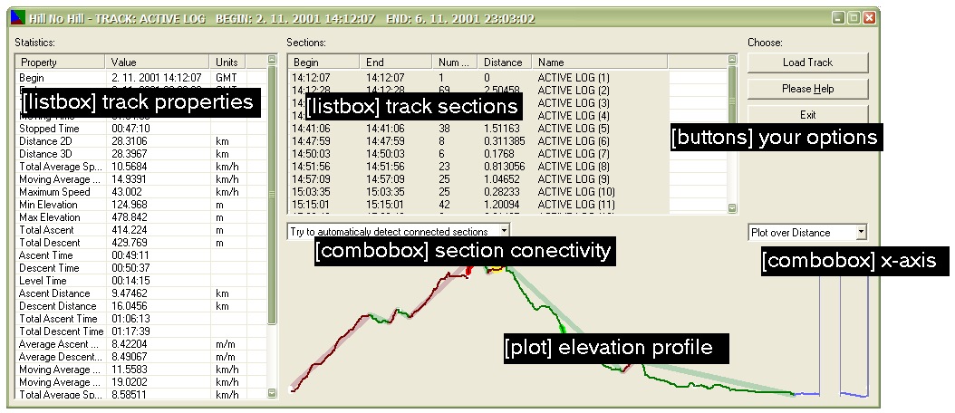
Track properties
The description of the individual properties is here.
Track sections
The list of the sections of the track. Select those that you wish to
examine.
Section connectivity
In the section connectivity combo-box you can choose from three possibilities:
Sections are not considered connected
Try to automatically detect connected sections
All sections are connected - this is just one track!
The last options tells the application that it should ignore the sections.
In this case the statistics are computed as if the track was traversed continuously
as a single trip. Whereas the other two options divide the track into more separate
trips. The difference is that between trips neither the time is counted nor the ascent
or descent or any other statistic. The track is considered as discontinuous in time
and/or space (more about this issue in the description of the individual statistics).
The difference between option 1. and option 2. is that in the first case all sections
are considered to be different trips and in the second case a "very smart" heuristic is
used to determine whether the section is a beginning of a new trip or not.
Elevation profile
In the area bottom left you can see the plot of the elevation profile of the track.
Use the X-Axis combo to select the x-axis parameter (either time or distance).
The colors used in the profile plot are explained in this picture:
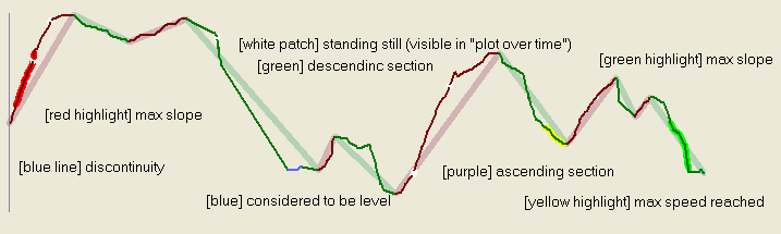
Vertical threshold
If you make a descent withing a ascending parth of the track that is below this threshold than the descent will be ignored in the statistics. Set this threshold to 0 if you want but I presonally like the threshold of 15 meters for my MTB tracks (don't forget to push the 'update' button).
Speed threshold
Below this threshold you are considered to be standing still - 1.8 is good for MTB but consider something like 0.5 for hiking (don't forget to push the 'update' button).
X-Axis
Select the x-axis value for the plot.
Buttons (Load Track/Please Help/Exit)
Should be clear.
Statistics
All statistics are computed only on the selected sections.
- Begin
- start time and date
- End
- stop time and date
- Total time
- total examined time
- Moving time
- time when the GPS was moving
- Stopped time
- time when the GPS was standing still
- Distance 2D
- total track distance (projected to a plane)
- Distance 3D
- total track distance
- Total average speed
- Average speed (Distance 3D/Total time)
- Moving average speed
- Average speed (Distance 3D/Moving time)
- Maximum speed
- maximum speed (kept for at least 20 seconds)
- Minimum elevation
- Maximum elevation
- Total ascent
- total of meters ascended (threshold used to eliminate small ascends in descent)
- Total descent
- total of meters ascended (threshold used to eliminate small descends in ascent)
- Ascent time
- time ascending
- Descent time
- time descending
- Level time
- time the GPS was moving at one level (well ... this happens very scarcelly - I will have to change the algorithm)
- Ascent distance
- the distance along the track while ascending
- Descent distance
- the distance along the track while descending
- Total ascent time
- ascent time (including standstills)
- Total descent time
- descent time (including standstills)
- Average ascent speed
- the average speed of ascending (vertical speed)
- Average descent speed
- the average speed of descending (vertical speed)
- Moving average speed in ascent
- the moving average speed in ascending parts of the track
- Moving average speed in descent
- the moving average speed in descending parts of the track
- Total average speed in ascent
- the total average speed in ascending parts of the track (includes standstills)
- Total average speed in descent
- the total average speed in descending parts of the track (includes standstills)
- Average ascent slope
- average slope (Total ascent/Ascent distance)
- Average descent slope
- average slope (Total descent/Descent distance)
- Maximum ascent slope
- maximum slope (at least 300 meters long)
- Maximum descent slope
- maximum slope (at least 300 meters long)